Reliant Systems Pty Ltd

FloodMon is a next generation web-based environmental monitoring system

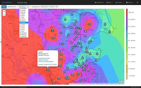
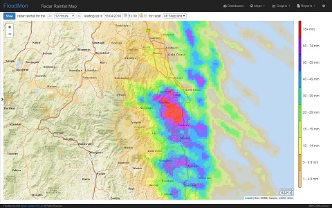
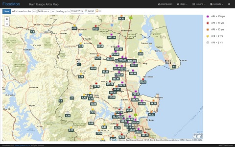
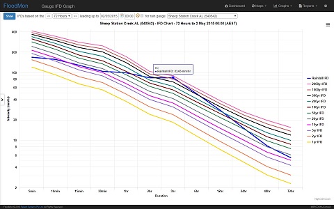
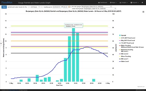
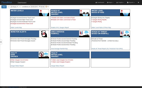
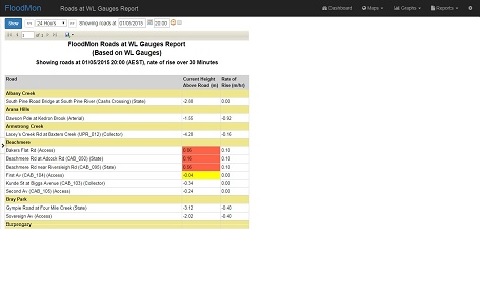
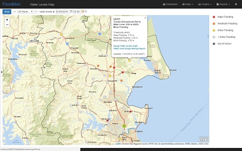
FloodMon is designed to improve councils’ situational awareness during weather events and assist post event analysis.  It accumulates and presents a wealth of real time information, including rainfall and water levels, wind gusts, IFD/ARI levels, forecasts, radar, charts, mapping and alerts.

Click image for FloodMon brochure

FEATURES

FloodMon is fast

FloodMon’s unique data architecture is faster than any comparable system. Most screens return results in less than a second.
FloodMon’s responsiveness means that users are able to see the big picture and then drill down to and move around areas of flooding concern, in seconds.

FloodMon is powerful

FloodMon's rainfall IFD/ARI processing engine can simultaneously calculate IFD/ARI levels at hundreds of locations, in less than a second. Area calculations and predictions can automatically calculate runoff loss amounts and be set in the future using BoM rainfall forecasts.

FloodMon gives you time

FloodMon’s unique combination of speed, ease-of-use and power gives decision makers their most valuable asset during weather events – time. Time to observe, time to decide and time to communicate.

FloodMon is easy to use

FloodMon’s screens are designed to be simple and intuitive to use, accessible by new and casual users with only limited instruction. Experienced users can custom adjust queries and displays.

FloodMon is flexible

FloodMon can either be cloud or in-house hosted, depending on your needs.

FloodMon has capacity

FloodMon can support hundreds of concurrent users and thousands of rainfall and water level gauges. FloodMon has practically unlimited storage of gauge readings, allowing for all historical and current readings to be stored in the one place.

FloodMon is connected

FloodMon’s flexible architecture connects to BoM gauges, BoM forecasts, BoM radar, legacy gauge systems, third-party systems and inexpensive 3G/4G/IoT gauges. FloodMon integrates with enterprise systems using industry standard REST style APIs.

FloodMon is reliable

FloodMon’s simple design and data capture mechanisms have proven to be reliable and trouble free. FloodMon continuously monitors the health of its connections to other systems and provides alerts and reports when connected systems or gauges are experiencing outages.

ARCHITECTURE

FloodMon Architecture

OPERATIONS

FloodMon has dozens of map, graph and report screens available, all of which are responsive and easy to use.  All screens show results instantly in real time.  Functionality can be tailored to individual users’ needs.

TESTIMONIALS

Moreton Bay Regional Council (MBRC) have dealt with Reliant Systems for approximately 6 years for support and development of enhancements to TARDIS (Pre FloodMon flood gauge data system).  In this experience, Reliant Systems have provided exceptional high quality and reliable service.

FloodMon has recently been installed at MBRC and I have found that it is a fantastic tool that incorporates many enhancements and refinements in features and tools making it exactly what we need for viewing, analysis and management of our flood warning gauge data.  It is simple and intuitive for even the most basic and non-technical user but includes advanced options for the flood engineers, making it a system that can be used throughout Council.

Leanne Salter
Moreton Bay Regional Council

Sunshine Coast Council uses FloodMon as the interface for its Flood Warning System. We have found it to perform extremely well and have exceptional reliability. The system has enabled us to improve our responsiveness in Disaster Management Operations by allowing us to effortlessly monitor our Flood Warning System remotely.

Reliant System have always been receptive to our needs and efficient in developing the FloodMon product. This has included the development of an API to enable FloodMon to publish data into other applications, as well as developing the system to interface with newer low cost sensor technologies. The inclusion of battery voltage, combined with alert capabilities and multi-site graphing, has allowed us to adopt FloodMon as the tool for the day-to-day management of the Flood Warning System, making it easier to identify sites that require attention.

FloodMon is more to us than an interface to our Flood Warning System. Importantly, it is the repository for all of the data that has been collected from the Flood Warning System over many years. FloodMon provides for the easy review of this data, as maps and graphs. The ability to select custom dates makes it very useful for reviewing historic events. It also allows this information to be extracted so that it can be used for other purposes, such as calibrating models.

Crispin Smythe
Sunshine Coast Council